
Leica Geosystems HDS
As Leica Geosystems HDS Authorized Distributor, SmartGeoMetrics is your source for the best selling brand in the laser scanning industry.
Leica Geosystems offers a best-selling hardware lineup and the Cyclone Software Suite has been an industry benchmark for point cloud processing. As a Leica Geosystems Authorized Distributor, SmartGeoMetrics has access to Leica's complete line of hardware, scanning accessories and software solutions. With the largest fleet of Leica HDS equipment in North America, SGM has the hands on experience that clients appreciate when they are looking for information about the best hardware and software to suit their needs. Leica HDS hardware and software is available to purchase or rent. Al-la-carte support is also available for most Leica HDS products.


-
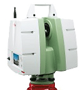
Leica P20- Ultra-high speed scanners (up to 1 million points/second) are known for their ultra-fast scan speeds and often higher level of detail. To this, the break-through, compact Leica ScanStation P20 also brings unprecedented data quality at range (120m, max), plus outstanding environmental capabilities, survey-grade tilt compensation, and an industry first "Check & Adjust" capability. With "Check & Adjust" users can electronically check the accuracy of their instrument and adjust it themselves to ensure the highest level of performance. > more
-
Leica C5 For organizations entering into laser scanning for as-built and engineering surveys, the affordable Leica ScanStation C5 represents a great starting platform: high performance laser scanner, power supply, data storage, touch screen interface, video camera, and laser plummet all in one instrument. Users can add additional performance and versatility over time to support expanding client opportunities. Leica ScanStation C5 owners can easily add longer range, even faster scan speed, high-accuracy dual-axis compensation for standard survey workflows, and a high-resolution internal camera for color mapping.
-
Leica C10 The versatile Leica ScanStation C10 includes a high-accuracy/long-range scanner, tilt sensor, battery, controller, data storage, auto-adjusting video camera and laser plummet all in one compact, portable instrument. The ScanStation C10 also features major productivity advances, including a Smart X-Mirror™ design that lets users conduct full-dome scans in literally a few minutes using a spinning mirror or conduct small area scans efficiently with Smart X-Mirror’s oscillating mode. With up to 300m range and unequaled versatility for site, exterior, and interior applications, the Leica ScanStation C10 makes High-Definition Surveying™ (HDS™) profitable for even more as-built, topographic, incident scene, and monitoring surveys. > more
-
All functions, including precision 3D scanning, extensive and precise total station capabilities, digital imagery and GNSS connectivity are now brought together in the Leica Nova MultiStation. A revolutionary solution with advanced measuring technology that provides unchallenged accuracy and quality, yet is easy to use for an unprecedented range of applications. The capabilities of the Leica Nova Multistation are truly comprehensive and second to none. > more
-
Leica Cyclone Software Suite The standard by which all other point cloud registration and modeling software is measured. Cyclone is available with multiple modules (Viewer Pro, Register, Survey, Model) so that you only pay for the features you need. Version 8 has now been released and offers advanced point cloud indexing over previous versions as well as an automated pipe extraction tool, Python scripting, and a customizable model library.
-
Leica Cyclone Topo II Designed for survey data processing Topo II has many features that aid in producing typical topographic and survey deliverables such as line tools, alignment cross-sectioning, and meshing.
-
Leica Cloudworx The Cloudworx family of products provides plug-ins for point cloud processing in many of the most popular CAD platforms including AutoCAD, Microstation, PDMS, Revit, SmartPlant 3D and SmartPlant Review. > more
Hardware
Software
-
Leica TruView & Cyclone Publisher TruView is a simple to use free web viewer for everyday professionals. TruView allows users to view, measure, markup, and add hyperlinks to point cloud data in a panoramic point cloud viewer. Cyclone Publisher is used to create the html based sites that are used by the TruView plug-in.
-
Leica Forensic Map Pro offers a single application to process and view data from laser scanners, total stations, and GPS for law enforcement and accident reconstructionists. Integrity of the evidence is maintained by using a data-basing system that tracks all changes. Specialty features include crash analysis calculators and animation tools.
